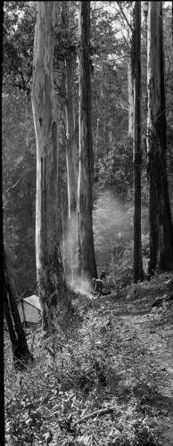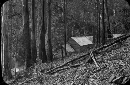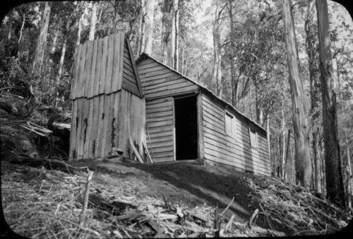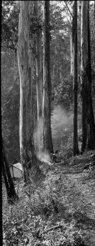
Anyone searching for this ‘lost’ ruin may be helped by these ‘new‘ photos which have just come to light, and these wonderful historical accounts. The three photos show the old hut. I presume the new hut was built very close by it. They show the hut to be much further up the ridge (not near the flat at all!) and much further up the Falls Creek valley than one might have imagined. The remains of the concrete chimney of the ‘new’ hut should be fairly obvious – even though the timber there is quite thick! (Photos as usual courtesy of Thomas Osburg).

See: http://finnsheep.com/THE%20UPPER%20YARRA%20WALKING%20TRACK.htm

Early Trips to Upper Yarra Falls: This is from 1911 with the writer looking back many decades. Yarra Falls was known as Panton Falls, then Campbell Falls and Falls Creek was once called Queens Birthday Creek:
Upper Yarra Falls: To the Editor of the Argus: Sir, Mr. Panton’s letter on the discovery of Mount Donna Buang, that appeared in “the Argus” of the lst inst, brought back to me recollections of the time-half a century ago when I was one of the many hardy prospectors who penetrated the dense scrubs and steep mountain ranges of the Upper Yarra, in search of gold. I have still a vivid recollection of the night -a most uncomfortable one-I passed with Mr. Panton on Queen’s Birthday Creek, on May 24, 1866; but I think that gentleman makes an error when he alludes to me as the discoverer of the falls near the head of the river.
I am under the impression that they were visited by a party of surveyors in the year 1845. I certainly re-discovered them in 1867, and named the waterfall (there are several) after Mr. Panton. It would be a graceful act to abandon the present name (Campbell) bestowed on the lower fall, long after my visit, and revert to the original one, as it would keep green the memory of a gentleman who did much to open up the Upper Yarra valley, and develop their mineral and other resources. Yours, &c., July 19. J. Blackburne.
Yarra Falls 1888. This is the middle part of a 3 part article. Leader (Melbourne, Vic. 1862 – 1918), Saturday 22 November 1884, page 16 The Contributor: An Excursion to the Upper Yarra Falls By G. No. II:
We struck camp next morning at half-past nine. Just after starting we noticed a tree marked W. From this we understood that we had been encamped on the two mile water. This made our march of the previous day a little over 8 miIes, The height of our camp measured by the barometer was 1700 feet above McMahon’s, We proceeded along the south watershed of the Yarra in a general easterly direction. The prevailing character of the country was the same as on the evening before, The track was often perceptible as a sort of avenue through the scrub, though in the clearest places knee deep in ferns and wire grass and obstructed by logs.
We passed through several saddles separated by small rills. At about twelve o’clock we could see a great spur coming in to join the ridge we were following from the north – that is on our left, This could be nothing else than the right watershed of Alderman’s Creek. We were, therefore, making good progress, and might hope to reach the Yarra that night. So we went on for another half hour, when our horse, in getting over a log, slipped and fell. He could not rise again with the pack and we had to unload him, but he was none the worse.
As we began to ascend the hill we found the sides and top of it covered with huge logs hundreds of foot long, as if it had been cleared by a survey party, The interstices between them were filled with tall bracken and scrub with white flowers, and the track seemed altogether obliterated. We made our way very slowly round and over the logs, and presently the horse got another fall, and we had to unload and reload again.
There was a good look out from many places down the valley of Alderman’s Creek and of the ranges across the Yarra, We found the top of this mountain was 1200 feet above our camp of the previous night, or about 4000 feet above the sea level. It is unnamed on the maps. We christened it Mount Horsefall. The fallen logs gave It a prevailing white appearance, but it contrasted with the pale green which had hitherto characterised the crest of ‘the range.
At about four o’clock we began to descend a little, and get into a forest, in which the beech tree was the prevailing timber, though largely mixed with tall gums and messmates. But little vegetation grows under a beech tree; what there was was the blue gum fern with the crimped frond I have noticed before. Moreover, the beech tree is seldom uprooted. It slowly decays as it stands and falls piecemeal, The ground in a beech forest is therefore encumbered by but little fallen timber.
As soon as we got under the beech trees the track improved very much. They were mingled, however, with very tall messmates, from which large quantities of dry bark in strips 4 or 5 inches across and 30 or 40 feet long or more had fallen to the ground, and lay in large coils. These continually tangled our feet, and it was difficult to get free of them, One would continually find one was dragging a tail behind many feet long. On getting under the beech trees the prevailing tints again changed. The black earth was bare, and varied shades of brown or dark green met the eye in every direction.Towards the south and east the slope was so steep that we got a look out over Gippsland as far as the ranges in the neighbourhood of Baw Baw. The earth seemed everywhere moist; in places one could hear the water under one’s feet. The track continued slowly to descend, and our view became shut in on all sides. About six o’clock we found ourselves in a saddle. This we identified upon our tracing as about 6 miles from our camp of the night before And 4 miles from the Yarra. It seemed a likely place to find water. There were a few beech trees and messmates on the saddle, and a forest of white gums, tall, slender poles like the mast of a ship, 300 feet high at the least, with a tuft of foliage at the top. There was a fern tree gully coming up to the saddle on each side. The earth was black and moist, and for the most part bare.
We found a good stream of water a little way down on the south side of the saddle, so we determined to camp. We pitched the tent under two beech trees, whose thick foliage would protect us from any sticks that might be blown off from the gums, and made our bed of fronds cut from the ferns. When we got up the next morning a strong north wind was blowing, shaking the tall, white ferns like corn stalks, bending them as if to break with a great roaring noise. We did not make a start until about half-past ten, when we at once began to ascend out of the saddle, and soon came out into the sunshine on to a hill covered with fallen timber and sword grass, and from which there was a good view of the opposite ranges. The logs had rotted and broken into fragments, and were therefore not the obstacle they had been on Mount Horsefall.
After a little we again descended into a beech forest. Here the track was clearer than we had yet found it. It was obstructed by little else than small sticks. There was a little of the usual green fern, but except for that the ground was clear of undergrowth on all sides. The dark foliage of the beech trees overhead shut out the sky. In order to keep the track it was necessary to keep a sharp look out for blazes.
After about a couple of miles gum trees again appeared mixed with the beech trees, and we were again troubled by fallen timber. About the same time we found growing in the track tall solitary stalks of grass like oats which shot up with a stem as thick as one’s finger, seven or eight feet high. Finding the horse would eat the two gathered bundles of it, as we went along. A little after twelve o’clock the horse got another fall getting over a log. We had to unload, and determined to have lunch.
When we again made a start we found it had been raining heavily, and that the scrub was very wet. In a little while we got out of the beech forest, and began to ascend a hill covered with tall standing gums and thick bracken up to our shoulders. Through this we pushed our way, getting drenched through. When we gained the top of the hill we found our track appeared to leave the ridge, and turn down the sideling to the north-east. After turning down on the sideling we were soon again in a beech forest, and out of the high wet bracken.
In about half a mile we came to tho creek, which was broad and shallow, scarcely covering the ground. It crossed the track from left to right- not from right to left, as marked in our tracing. The descent from the ridge to this creek was not more than 200 or 300 feet, and not at all steep, considering it was on a sideling. We crossed the creek and ascended to tho ridge on the opposite side. Crossing it we descended on a sideling to the Yarra, which we at once passed over. It was a much smaller stream than that we have left at McMahon’s, being about 30 feet wide and about up to our ankles, with, however, a good current.
The scene was a peculiar one. It was still raining hard. Heavy clouds rested on the tops of the beech trees from 50 to 70 feet above us, which lined the river banks and covered the slopes, and hung in festoons between them, but below it was clear. We had no time to stand and watch it, however, being wet through. We had to get to work and camp at once. In about twenty minutes we had a fire big enough to roast an ox. Having pitched our tent we looked about for something to make a bed of, and the best thing we could find was a heap of bark at the foot of a neighbouring messmate. This we dragged in front of the fire and dried, after which we had our evening meal round the fire. We stood up round it for some time drying clothes, while the horse stood warming his nose on the opposite side of the fire. Finally we turned in.
We were up at six the next morning. There was still a slight rain, We had breakfast, and at half-past eight we started in search of the falls. Our camp was shown by the barometer to be 2100 foot above McMahon’s or only 500 feet lower than the top of Mount Horsefall. It was distant from Reefton by the road we had come just 20 miles, or in a straight line about 15. Now, the Yarra did not change its level to any great extent between McMahon’s and Reefton, or for some miles above the latter place. The difference in elevation therefore gave room for a high fall. Moreover, the country we were in appeared to be an elevated plateau, to which we had ascended abruptly at Mount Horsefall, and which would probably come to an abrupt termination.
We accordingly started down stream, crossing a considerable tributary on the right bank just below our camp, Tho river ran through a beech forest, and as nothing will grow under the beech trees, its banks were without that fringe of peculiar vegetation which is usually such a marked feature in an Australian river or creek. After a little we went over to the left bank, and crossed a small creek which joined the river on that bank, we then came upon a series of small hills, perhaps altogether fifty or sixty, There was, however, a good indication of something better. We could see a light through the trees ahead as from a largo clearing. This appearance could only be occasioned by the edge of an abrupt declivity.
We pushed on and soon began to get glimpses of a valley a long way below us, and to hear tho roar of a great fall. The beech forest ceased with the edge of that declivity, and the slopes below, when not too steep and bare for anything either to grow or stand on, were covered with undergrowth, mostly ti-tree. To see the fall we must get below it. We accordingly descended as rapidly as a regard for our necks would permit several hundred feet, and made our way on to a ledge down to the water. From this point we could see the water falling above and below us over a face of dark rocks in a series of steps. The fall was shaded by ti-tree, with occasional tree ferns on the ledges. The spray fell like rain. We were too close to the face of the fall, and tho ledge we were on would not permit us getting further out.
We were not the first persons who had viewed the Yarra falls from this spot, for we saw a tree with a blaze on it, on which was a name, partly overgrown with bark, which we made out to be A. Burns. We then crossed over, scrambled along the face of the cliff and made our way down another hundred feet or two, and got another view of the falls, with, however, the disadvantage that we were too close to see far up or down. This point was by the barometer 550 feet below the top of tho fall. We could see the fall for about 50 feet below it. It was a continuous fall all the way, interrupted only by small ledges. There is, however, no reason to suppose that the lowest point to which we could see was anywhere near the bottom of the fall. Judging from the appearance of the valley it was far from being so. The total height of the fall therefore, can scarcely be less than 700 feet or 900 feet; it is probably 1000 feet.
We had not seen by any means as much of the falls as we should have liked, but we were compelled to return. It was Tuesday, and R. had to be In a distant part of Victoria by the following Monday morning. For this purpose it was necessary that he should be in Melbourne by Saturday. We could scarcely do this unless we moved on that day. Moreover, our oats were running out, and there was not a scrap of feed at our present camp, while our tracing showed that on the Thompson, 4 miles on, there was grass. We accordingly turned back towards our camp.
In returning we got a view of a great cascade, forming the top-most rip on the fall, which we had not seen going down. By half-past one we had regained our camp. We then bathed in the Yarra, had lunch, struck our camp, and started for the Thompson, where we hoped to camp that night. It was shown by our tracing to be 4 miles distant. The track in the first instance followed the ridge of the very low spur between the main arm of the Yarra and tho tributary that joined it just below our camp. After a little the track forked; we took, the left fork, which took us down to the tributary at a point where two creeks united to form it; beyond this the track was not apparent.
After a little we found a place where a tent had been pitched, with a rude platform of round timber to raise it off the ground. We had evidently come upon an old surveyor’s camp. That explained how it was that the track ran out. We accordingly returned and took tho right hand fork of the track. After we had gone about three quarters of a mile the track turned down to and crossed the creek on our left, and shortly afterwards began to ascend a ridge on a sideling. The top of this ridge was not. more than 100 feet or so above our camp. On it we found white gum timber. The ridge was narrow, and the track immediately descended on a sideling on the other side, about 300 feet into a narrow valley containing a fine stream of water. The sides of the valley were lined with beech trees, with a few tree ferns. This creek must form the right fork of the Yarra as laid down on the maps; and as its level appeared lower than the top of the falls, must join, the left fork below them.
Crossing the creek we ascended on a steep sideling on the other side to a height somewhat greater than that from which we had descended, and found ourselves in a forest of white gums mixed with beech trees, with a good deal of undergrowth. The creek, however, continued tolerably clear. We were now upon the crest of the dividing range, between the waters of the Yarra and the Thompson, marked on the maps as Wright’s Range. A little before seven o’clock the track began to descend gently, and we reached a fine stream of water crossing the track from north to south, spanned by a good log bridge. This stream, which was much larger than either fork of the Yarra, or, I should say, than both of them together, we made out to be the Thompson. Here we determined to camp.
A little way up from the river, to the right of the track we had come by we found an open glade carpeted with good grass. On this were the remains of an old survey camp, consisting of log platforms, similar to that we had noticed on the Yarra. There appeared to be a succession of rich glades along the river, divided only by low scrub, tall timber not being found till some little way up the slopes on either side. There was, therefore, a clear view up and down tho river for some way over the top of the scrub. We could see the sky, too, overhead and in front of us. All this was a change after the dense grass through which we had been traveling for the last four days, The edge of the other valley was lined with large white gums, say 100 foot high, with straight, thick limbs tapering to the top, and wide spreading arms a little more than half way up. The slopes behind were covered with a mass of plants of different kinds. Every here and there above this rose to a great height huge logs, white with age and black with fire, without limbs, broken at the top.
Though generally impressed by the view, there was a feeling of solitude connected with this camp not experienced elsewhere in the course of this trip. The height of this camp was 2300 feet above McMahon’s, or only 100 feet lower than our camp on the Yarra. We were still, however, above a high plateau, as high or higher than the top of Mount Macedon. We were now about 23 miles from Reefton, and about 14 from Mount Lookout. (Thanks once again to Thomas Osburg for these accounts)

