I have always loved Shelley’s poem ‘Ozymandias’ which showcases the futility of Pharaoh Rameses’ efforts to secure his immortality. Many people these days are obsessed with mankind’s (supposed) destruction of nature, an observation which I do not wholly disagree with, but nature has a way of coming roaring back, all but obliterating mankind’s works.
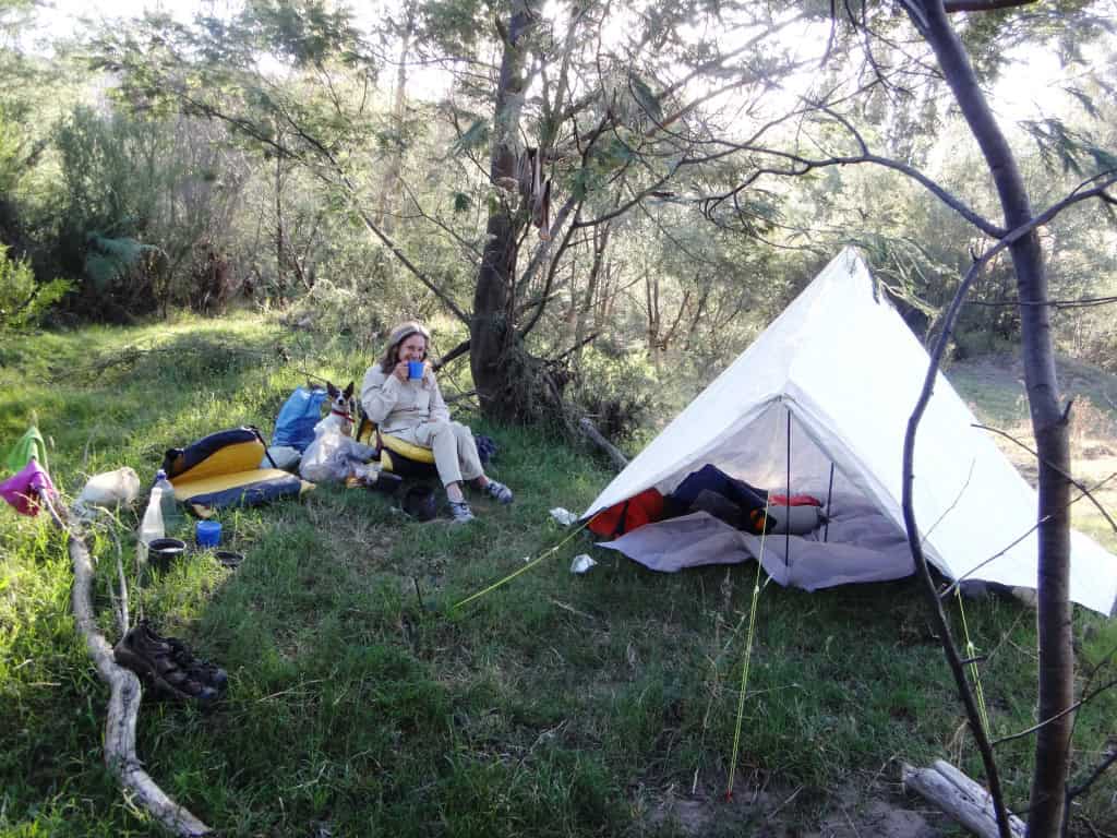
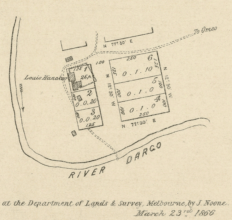
For example, along the eighty or so kilometres of the Dargo River in East Gippsland above the point where we are pictured camping there were quite a number of (mainly gold mining) settlements along its length which are extremely difficult to find today. Apparently it is possible to download maps of some of them (eg Loiusville, Brocket) from Victoria’s State Library, georeference them and after some days of hard-scrabbling to get there, and manage to stub your toe on the foundations of an old building now mouldering into the thick ferny regrowth.
Camped near the Dargo River confluence:

It is an adventure I would like to have before I die though I will probably try a few somewhat easier exercises first. I know a few abandoned sites along the Aberfeldy River (closer to me) below Beardmore’s Bridge (for example) that I should be able to visit in day or anyway in a very enjoyable overnight expedition. I know of at least two mine sites and two hut sites there as well as an abandoned river diversion tunnel. Some I stumbled upon forty or more years ago as I raced down to where my hounds had a deer bailed up. I found others others in a similar way above the bridge including a very large stamping battery below Fulton’s Track.
I do still also plan to revisit the forbidden Yarra Falls and the ruins of its Shelter Houses even though doing so can occur an almighty fine. it is (probably) Victoria’s tallest waterfall (at nearly a thousand feet – 300 metres) and used to be pretty much our premier tourist attraction before it was (quite unnecessarily) closed after WW2 to build the Yarra Dam. I would like to obtain some better photographs (at least) than those I have so far and once again enjoy a fresh trout from the headwaters of the Yarra River for my dinner (despite the many leeches). See for example: Yarra Falls Shelter House & Yarra Falls & Yarra Falls 3.
Years ago while hunting there I found a battery and abandoned railway line in Deep Creek (not far from Walhalla). There was a stamping machine, boiler and a number of railway skips I remember but as I only chanced there for a bail-up I did not explore it overmuch. I remember walking out along the line of the railway track. It had clearly been a timber line with a strip of flat iron on the top to stop the timber from wearing away. This much was obvious from the coils of curled up strap which bushfires had heated and scattered around the hillside. I clearly remember though coming across a huge gum whose trunk completely blocked the railway easement, the kind of tree which folk claim to be thousands of years old – yet clearly it had grown up since the gold rushes there in 1866! If there is a cool day in the next few weeks when I can take a break from house building Della and I will take a walk in there again with the dogs to get some pix of it for you.
Even here at home on our little farm further up the creek the land, once cleared has all run back to bush. Sometime in the C19th there was a copper mine about a kilometre up. I know where the shaft is just by the waterfall. You have to be careful not to fall into it. Years ago we placed a barrier around it thinking of the kids. Apparently they used to have a retort at the other end of our flat where they did some refining. The old lady who used to live here (Mrs Sawyer) collected all the bricks back ion the 1930s to make a path in front of her house – the old cottage which I am restoring/renovating. She brought them down in her pram. There are still some around. I used some when I was jacking up the house/cottage to restump it last month.
Again during the le C19th people discovered a seam of black coal under the hill further up the creek but on the opposite side to us. They planned to mine the coal and supply the Victorian railways which were just getting started but they failed to get the contract so it was never developed. All that remains to show that this was so is the name Tramway Road leading towards us which would have been used to transport that coal. I have a lithograph an old neighbour gave me of the adit of the mine but I have never been able to find any evidence of it up the creek even though I have done a lot of work there making a private walking track for the family & etc in the bush which makes a very pleasant excursion on a hot day. See The Creek
The upper Dargo River is an awesome trackless wilderness in Victoria: A few years ago Wild Exposure magazine had an account of these two guys on a Dargo River Canoe Trip starting just a few hundred yards from Mt Hotham would you believe and traveling past all these wonderful lost places (Louisville, Brocket etc) all the way to Dargo. What an adventure! Do have a look at it. Here is a satellite view of the area so you can zoom in to see what is there and how you might get there. And here is an excellent discussion of the possibilities involved. There are some amazing photographs which I cannot reproduce here.
You can get the Brocket (above) and Loisville (below) survey maps for 1866 from the State Library. It would be possible to georeference them and then walk in to the location. The best routes are clearly from the ridges to the East (Boiler Plain & etc.) There were a number of other settlements along the river Verdon, Centreville China Flat, Miner’s Flat, Mayford & etc. You can drive to Mayford (and Miner’s Flat) but it is too difficult to walk up the river from there. NB once there was clearly a ‘road’ from Brocket to Omeo. It may be possible to relocate the line it took.


One of the contributors to this Discussion Page gives the exact locations of some of the places you may find, “Loiusville is at -37.05138, 147.14057 At the confluence of Freezout creek and the Dargo. Brocket is at -37.03827, 147.15038 they rerouted the river for a sluice here. There are a few batteries upstream on the Dargo and a few surveyed properties ( toward Freezeout) here -37.03339, 147.14099”
This brochure notes, “At Paw Paw Plain a significant mining track accessed Morris’s deep lead workings at Boiler Plain and the mining townships of Louisville and Brocket on the Dargo River. This route was in regular use during the 1860s and 70s and continued to be used to access the Boiler Plain mine into the 1890s”
This pic shows Rooftop’s map of the area under discussion:

Here is an old topo map which shows a closed road coming off the Alpine Way about 4km west of Dinner Plain (opposite Mother Jamieson Flat). If it can be located and followed it will take you to the South West corner of Boiler Plain only up the ridge 1 km from Brocket. T8323-4-1 From that point it should be possible to locate the old miner’s tracks which came up from there and Louisville.
NB. Even though it is only about 6 km from the Alpine Way to either of these abandoned townships I would take plenty of water with me as the going may well be much slower and more difficult than you might expect.
