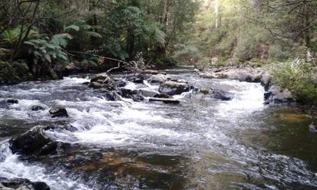
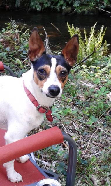
Escaping the heat: The Western Tyers is the BEST place I know to spend a couple of hot days: nestled under the South face of Mt Baw Baw, enclosed by Antarctic Beech and majestic Mountain Ash, it is always a lovely spot on such a day. You can brave the icy water (if you dare) or just lounge around in the shade on a folding chair, betimes catching the odd spinyback crayfish or mountain trout – or a platypus if your fancy so takes you: the dogs bark at them but have so far failed to bag one. I have wondered how platypus tails would GO with lobster tails!
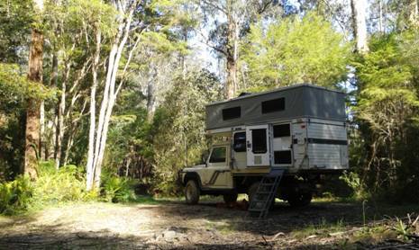
To get there you head up the main road to Erica from Moe, take the Tanjil Bren turn-off just after Wild Cow Track, travel 13 km and turn right at the first track after the 13 km post (Palmers Track, not signposted) shortly after Beynons Creek Rd. Palmers Track is fine (but not after rain) for light SULs such as Subarus down to the river at the old Palmers Mill/Bridge sites where there are two campsites. The Western Tyers ROAD (!) along the river is now only suitable for real 4WDs, though 30 years ago when we discovered it lots of folks made it in Kingswoods!
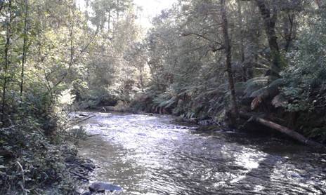
The Western Tyers Rd parallels the river for many kms usually less than 10 metres away. There are a number of pleasant unofficial campsites. It IS possible to canoe the river from Growlers (possibly from Christmas Creek – another fine campsite) down to the old bridge at Western Tyers and I have done so many times years ago, though I doubt anyone else ever has. There is a spectacular (@ Grade 4) chute and drop just below Growlers where the old rail line diverged from the road. It is possible to walk around it.
You can walk the old rail line down to Palmers (rough going nowadays) but you will catch many trout etc in that remote stretch of river. I planned once to clear the river for canoeing all the way from eg Growlers to the Morwell Pumping Station at Wirilda Park (off the Tyers-Yallourn North Rd). I have from time to time cleared sections of it and canoed others. I estimate it would produce a trip of around a week’s duration containing some superb fishing and some wonderful campsites – and so CLOSE! I did some work on a couple of the worst bog holes on the Western Tyers Rd (to make them navigable) and will do some more next time I am there, (soon I hope). The kids will want to come next time after they see the crays we brought home this time!


Hi there, not sure if you’re checking this site still. I’m local to Traralgon and looking to head up where you’ve described above. I’ve plotted it on a map and will be heading up this coming Saturday. I suppose I’m here to say thank you, and to see if you’ve been in the area recently or would like an update.
Cheers,
Sarah
Hi Sarah, You are commenting on a very old post but I do update the website almost every week. We were up that way a couple of months ago and saw that DOC had created a ‘new’ campground opposite Western Tyers (off Buckle Spur). The Western Tyers Rd downstream from Palmers Track is in very poor condition. Yes thanks. Happy for an update. Have a great trip. Cheers, Steve.
Cheers Steve.
I did see that this was a very old post but wanted to try my luck, looks like it paid out. I’ve been having trouble finding your social media to contact you on.
I went out for a scope today with my 2yo (you can imagine I didn’t manage to get a lot done) and found a great entry point to the creek from the Seninis campground, which seems to be a little way down stream of where you’re suggesting.
I did drive up to what I thought was the river crossing side (south side) of Western Tyers campground, however when I reached the junction from Benyon Creek Road I was unable to continue due to a gate. I’m going to have a look at access from from Palmers Track or perhaps even try to come in from the east at Caringal Scout Camp. I’m very interested in fishing that small stretch you described along Western Tyers River Road.
Cheers again,
Sarah
Hi SDarah, You can come over the hill (2WD) from Carringal instead of Beynon’s Creek Rd. The private gate can be ignored. There are some interesting (commune) cottages scattered around in the bush near there. There is a walking bridge across the small stream just after the gate then you can walk up the river and fish to your heart’s content all the way to Growlers (or Christmas Creek) if you want. BTW If you walk downstream along the river from the gauge (there used to be a walking track all the way to Carringal) you will come across a very interesting (huge) ‘chimney’ after about 100 yards – a wonderful photographic opportunity. Feel free to ‘fix’ the road downstream from Palmers if you have the time. Happy exploring. Good to hear from you. Cheers, Steve & Della.
Hi Steve and Della, I’m a joint owner of the property off Beynon’s creek Rd. It’s PRIVATE property, please do not access the river by going through the gate. Do not ignore the gate. PLEASE remove the instructions on your blog for accessing the river via our property.
As well as privacy issues, we are concerned about unregulated movement of people, vehicles and dogs on the property because there are some very sensitive areas with endangered flora and fauna, we manage the block to protect these values. The whole property was logged in the 1960s. The reason it looks the way it does today is because it has been carefully managed for biodiversity. You seem to appreciate the beauty and natural values of this area, we hope from now on you will respect our private property and help us preserve its important natural values.
Hi Dan, You will need to fence it if you want to keep people out and have it deemed ‘private property’. You can ask people to leave if they are trespassing but if they don’t you won’t be successful in prosecuting them unless it is fenced. Cheers, Steve.PS: I have never seen any signs of ‘management’.
Does it get slippery with the mud in winter, or are the roads and walking tracks generally OK? ( I am slowly gathering warmer gear to cope with cold if we are camping out and hiking in winter one day too)
I have not been able to beat Montbell for warmth/lightness. I will do a post about that. And about adding down to sleeping bags – which I am about to do. I find my -1C Montbell bag with a liner is fine for most winter occasions (down low). Sometimes I wear my down jacket on my upper body and my down vest on my lower. I have down socks (I never need them, but Della does). We both have insulated hats. Hers is down. Mine is Primaloft. Some of the tracks for the Upper Yarra Track winter route (I guess that’s what you mean) are too wet for most 2WD cars in the winter, but will be fine for walking. You can drive past Carringal to Western Tyers (gravel road – might be slippery in 2WD) and take a walk from there for a day trip. Just walk through the gate and continue on along the river road. Take a rod. If you have one of the urban 4WDs, slippery gravel roads are just what they are for. A set of snow chains or two will get you a long way. You just have to be sensible and careful. Some lovely walks around Tanjil Bren. accommodation at the Moose Lodge. Tar to Tanjil Bren, then walk. Lots of lovely places in Gippsland. Have you been to the Ada Tree? (2WD) You can walk along the river all the way back to Warburton (see Upper yarra Track Instructions). Winter will be fine for low down walks like that. Have fun. Good luck. Cheers, Steve.
I am still getting so much out of reading your blog – thank you so much for sharing with us all. I have never been to this area, but as it is close (to Eastern suburbs), it sounds very inviting for taking a relaxing weekend, camping and exploring over Summer.
Thank you Jenny. Gippsland is way the best part of Australia. No need to wait for summer to visit. There are many wonders all year round. I am hoping to get away for a few days over the next week or so to camp along one of our great rivers – at only 300 metres above sea level and with ample firewood and winter temperatures at night rarely below freezing, yet often beautiful days winter is a great time to visit. Many people even canoe mostly in winter as there is more water then (they wear a wet suit). Good luck with your explorations. Cheers, Steve.
A few years back myself and two mates kayaked this river. We figured it would be too thick up higher so put in at W12 track and ended at Wirilda Park. We paddled it with no expectations and came off the river with smiles all round. Some nice rapids, clear clean water and no real hazards to speak of. Will get back on it one day. Maybe try the upper reaches of this river.
Great. Most of that section I had already done work on – though it needs more again now. Take these with you next time and maybe after a while we can have a heap of canoeable small rivers: http://www.theultralighthiker.com/canoe-clearing/